Warn’Ops anti-drone and telecom

Real-time GPS driven software that displays the range of an offensive jammer according to terrain obstacles.
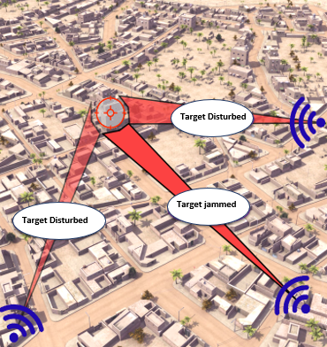
► FEATURES
- Display of the jammer’s range according to the environment
- Optimization of jammers spatial distribution
- Best range zones calculation, live and prior to missions
► COMPETITIVE ADVANTAGES
- Real-time display (< 1 s)
- Precision (< 1 m) – GPS driven
- Customized human-machine interface
- Compatible with all active/reactive jammers
- Compatible with all embedded IT systems
► ENTRIES
- Jammer parameters
- Metric digital elevation model
- Orthophotos
- GPS (compatible with NMEA 0283)